

![[backarrow]](b_arrow.gif) :tilbake til hovedsida..........jump to the English main page:
:tilbake til hovedsida..........jump to the English main page:
![[english-arrow]](c_arrow.gif)

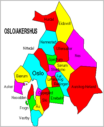
Oslo and Akershus counties
Below you'll find
- a map showing the county and all of its municipalities,
- a table showing the population and size of each municipality.
NB: Both on the map and in the table Oslo has been shown together with its very close neighbour county Akershus.
As a basis for this map is used a .bmp-file in a program called HYPERNOR v. 1.0., distributed by Programvareklubben MCS, Pb. 3541, 7002 Trondheim, Norway. Some corrections and the adaptation to HTML has been done by Johan I. Borgos. (Please include this statement if you copy this page and use it on a website or on printed matters.)
The municipalities
Source: Statistisk sentralbyrå
| Municipality | Pop. 1990 | Pop. 2000 | Km2/miles2 |
|---|---|---|---|
| 0301 Oslo | 458 364 | 507 467 | 454/175 |
| 0211 Vestby | 11 286 | 11 815 | 134/52 |
| 0213 Ski | 22 300 | 25 394 | 166/64 |
| 0214 Ås | 11 917 | 13 568 | 103/40 |
| 0215 Frogn | 10 113 | 12 972 | 87/34 |
| 0216 Nesodden | 13 063 | 15 448 | 60/23 |
| 0217 Oppegård | 20 313 | 22 953 | 37/14 |
| 0219 Bærum | 89 221 | 101 494 | 192/74 |
| 0220 Asker | 41 360 | 49 284 | 101/39 |
| 0221 Aurskog-Høland | 12 596 | 12 561 | 961/371 |
| 0226 Sørum | 11 245 | 12 133 | 207/80 |
| 0227 Fet | 8 612 | 9 271 | 176/68 |
| 0228 Rælingen | 13 696 | 14 493 | 71/27 |
| 0229 Enebakk | 8 060 | 8 680 | 232/90 |
| 0230 Lørenskog | 26 066 | 29 505 | 71/27 |
| 0231 Skedsmo | 33 679 | 38 701 | 77/30 |
| 0233 Nittedal | 16 114 | 18 639 | 187/72 |
| 0234 Gjerdrum | 3 778 | 4 554 | 83/32 |
| 0235 Ullensaker | 18 121 | 20 160 | 252/97 |
| 0236 Nes | 15 729 | 16 288 | 639/247 |
| 0237 Eidsvoll | 16 627 | 17 524 | 456/176 |
| 0238 Nannestad | 7 992 | 8 967 | 341/132 |
| 0239 Hurdal | 2 545 | 2 648 | 285/110 |
Up to the map!