

![[backarrow]](b_arrow.gif) :tilbake til hovedsida..........jump to the English main page:
:tilbake til hovedsida..........jump to the English main page:
![[english-arrow]](c_arrow.gif)

Hedmark county
Below you'll find
- a map showing the county and all of its municipalities,
- a table showing the population and size of each municipality.
As a basis for this map is used a .bmp-file in a program called HYPERNOR v. 1.0., distributed by Programvareklubben MCS, Pb. 3541, 7002 Trondheim, Norway. Some corrections and the adaptation to HTML has been done by Johan I. Borgos. (Please include this statement if you copy this page and use it on a website or on printed matters.)
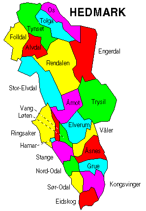
The municipalities
Source: Statistisk sentralbyrå
| Municipality | Pop. 1990 | Pop. 2000 | Km2/miles2 |
|---|---|---|---|
| 0402 Kongsvinger | 17 480 | 17 349 | 1 038/401 |
| 0403 Hamar | 25 356 | 26 545 | 351/136 |
| 0412 Ringsaker | 30 956 | 31 622 | 1 280/494 |
| 0415 Løten | 7 067 | 7 188 | 370/143 |
| 0417 Stange | 17 611 | 17 928 | 725/280 |
| 0418 Nord-Odal | 5 335 | 5 089 | 508/196 |
| 0419 Sør-Odal | 7 378 | 7 349 | 517/200 |
| 0420 Eidskog | 6 470 | 6 409 | 641/248 |
| 0423 Grue | 5 881 | 5 442 | 839/324 |
| 0425 Åsnes | 8 528 | 8 112 | 1 041/402 |
| 0426 Våler | 4 372 | 4 063 | 705/272 |
| 0427 Elverum | 17 332 | 18 046 | 1 229/475 |
| 0428 Trysil | 7 330 | 7 069 | 3 016/1 164 |
| 0429 Åmot | 4 458 | 4 379 | 1 339/517 |
| 0430 Stor-Elvdal | 3 371 | 3 012 | 2 167/837 |
| 0432 Rendalen | 2 499 | 2 257 | 3 178/1 227 |
| 0434 Engerdal | 1 721 | 1 580 | 2 195/847 |
| 0436 Tolga | 1 898 | 1 812 | 1 122/433 |
| 0437 Tynset | 5 356 | 5 473 | 1 870/722 |
| 0438 Alvdal | 2 434 | 2 417 | 944/364 |
| 0439 Folldal | 2 022 | 1 814 | 1 275/492 |
| 0441 Os | 2 029 | 2 148 | 1 039/401 |
Up to the map!