

![[backarrow]](b_arrow.gif) :tilbake til hovedsida..........jump to the English main page:
:tilbake til hovedsida..........jump to the English main page:
![[english-arrow]](c_arrow.gif)

Buskerud county
Below you'll find
- a map showing the county and all of its municipalities,
- a table showing the population and size of each municipality.
As a basis for this map is used a .bmp-file in a program called HYPERNOR v. 1.0., distributed by Programvareklubben MCS, Pb. 3541, 7002 Trondheim, Norway. Some corrections and the adaptation to HTML has been done by Johan I. Borgos. (Please include this statement if you copy this page and use it on a website or on printed matters.)
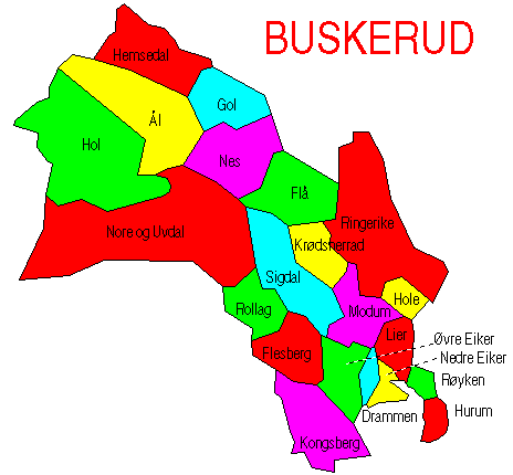
The municipalities
Source: Statistisk sentralbyrå
| Municipality | Pop. 1990 | Pop. 2000 | Km2/miles2 |
|---|---|---|---|
| 0602 Drammen | 51 978 | 54 816 | 138/53 |
| 0604 Kongsberg | 21 179 | 22 293 | 793/306 |
| 0605 Ringerike | 27 275 | 27 917 | 1 553/600 |
| 0612 Hole | 4 485 | 4 977 | 195/75 |
| 0615 Flå | 1 198 | 1 102 | 705/272 |
| 0616 Nes | 3 410 | 3 528 | 810313 |
| 0617 Gol | 4 232 | 4 390 | 533/206 |
| 0618 Hemsedal | 1 609 | 1 958 | 753/291 |
| 0619 Ål | 4 898 | 4 789 | 1 172/453 |
| 0620 Hol | 4 726 | 4 642 | 1 868/721 |
| 0621 Sigdal | 3 742 | 3 556 | 842/325 |
| 0622 Krødsherad | 2 387 | 2 254 | 375/145 |
| 0623 Modum | 12 262 | 12 366 | 517/200 |
| 0624 Øvre Eiker | 14 695 | 15 058 | 458/177 |
| 0625 Nedre Eiker | 18 797 | 20 502 | 120/46 |
| 0626 Lier | 18 780 | 21 308 | 303/117 |
| 0627 Røyken | 14 246 | 16 245 | 112/43 |
| 0628 Hurum | 7 962 | 8 363 | 163/63 |
| 0631 Flesberg | 2 552 | 2 491 | 562/217 |
| 0632 Rollag | 1 455 | 1 492 | 450/174 |
| 0633 Nore og Uvdal | 2 903 | 2 764 | 2 508/968 |
Up to the map!