

![[backarrow]](b_arrow.gif) :tilbake til hovedsida..........jump to the English main page:
:tilbake til hovedsida..........jump to the English main page:
![[english-arrow]](c_arrow.gif)

Vestfold county
Below you'll find
- a map showing the county and all of its municipalities,
- a table showing the population and size of each municipality.
As a basis for this map is used a .bmp-file in a program called HYPERNOR v. 1.0., distributed by Programvareklubben MCS, Pb. 3541, 7002 Trondheim, Norway. Some corrections and the adaptation to HTML has been done by Johan I. Borgos. (Please include this statement if you copy this page and use it on a website or on printed matters.)
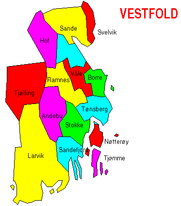
The municipalities
Source: Statistisk sentralbyrå
| Municipality | Pop. 1990 | Pop. 2000 | Km2/miles2 |
|---|---|---|---|
| 0701 Borre | 22 507 | 23 764 | 69/27 |
| 0702 Holmestrand | 9 144 | 9 384 | 86/33 |
| 0704 Tønsberg | 31 275 | 34 716 | 106/41 |
| 0706 Sandefjord | 35 888 | 39 317 | 122/47 |
| 0709 Larvik | 38 019 | 40 386 | 530/205 |
| 0711 Svelvik | 5 930 | 6 284 | 58/22 |
| 0713 Sande | 6 934 | 7 377 | 178/69 |
| 0714 Hof | 2 711 | 2 891 | 164/63 |
| 0716 Våle | 3 885 | 4 219 | 85/33 |
| 0718 Ramnes | 3 450 | 3 717 | 139/54 |
| 0719 Andebu | 4 380 | 4 678 | 186/72 |
| 0720 Stokke | 8 814 | 9 557 | 118/46 |
| 0722 Nøtterøy | 18 009 | 19 601 | 59/23 |
| 0723 Tjøme | 3 855 | 4 505 | 38/15 |
| 0728 Lardal | 2 406 | 2 379 | 278/107 |
Up to the map!