

![[backarrow]](b_arrow.gif) :tilbake til hovedsida..........jump to the English main page:
:tilbake til hovedsida..........jump to the English main page:
![[english-arrow]](c_arrow.gif)

Aust-Agder county
Below you'll find
- a map showing the county and all of its municipalities,
- a table showing the population and size of each municipality.
As a basis for this map is used a .bmp-file in a program called HYPERNOR v. 1.0., distributed by Programvareklubben MCS, Pb. 3541, 7002 Trondheim, Norway. Some corrections and the adaptation to HTML has been done by Johan I. Borgos. (Please include this statement if you copy this page and use it on a website or on printed matters.)
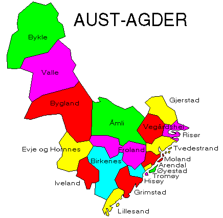
The municipalities
Source: Statistisk sentralbyrå
| Municipality | Pop. 1990 | Pop. 2000 | Km2/miles2 |
|---|---|---|---|
| 0901 Risør | 6 995 | 7 000 | 191/74 |
| 0904 Grimstad | 15 522 | 17 821 | 304/117 |
| 0906 Arendal | 37 791 | 39 446 | 272/105 |
| 0911 Gjerstad | 2 604 | 2 509 | 323/125 |
| 0912 Vegårshei | 1 839 | 1 838 | 356/137 |
| 0914 Tvedestrand | 5 885 | 5 967 | 217/84 |
| 0919 Froland | 4 120 | 4 497 | 642/248 |
| 0926 Lillesand | 8 036 | 8 816 | 185/71 |
| 0928 Birkenes | 4 002 | 4 290 | 675/261 |
| 0929 Åmli | 1 999 | 1 862 | 1 143/441 |
| 0935 Iveland | 1 155 | 1 128 | 261/101 |
| 0937 Evje og Hornnes | 3 378 | 3 346 | 561/217 |
| 0938 Bygland | 1 396 | 1 351 | 1 331/514 |
| 0940 Valle | 1 430 | 1 439 | 1 289/498 |
| 0941 Bykle | 728 | 868 | 1 461/564 |
Up to the map!