

![[backarrow]](b_arrow.gif) :tilbake til hovedsida..........jump to the English main page:
:tilbake til hovedsida..........jump to the English main page:
![[english-arrow]](c_arrow.gif)

Vest-Agder county
Below you'll find
- a map showing the county and all of its municipalities,
- a table showing the population and size of each municipality.
As a basis for this map is used a .bmp-file in a program called HYPERNOR v. 1.0., distributed by Programvareklubben MCS, Pb. 3541, 7002 Trondheim, Norway. Some corrections and the adaptation to HTML has been done by Johan I. Borgos. (Please include this statement if you copy this page and use it on a website or on printed matters.)
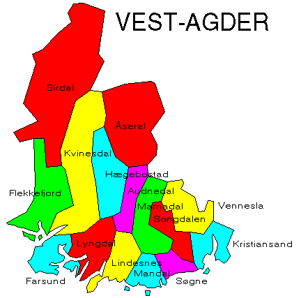
The municipalities
Source: Statistisk sentralbyrå
| Municipality | Pop. 1990 | Pop. 2000 | Km2/miles2 |
|---|---|---|---|
| 1001 Kristiansand | 64 888 | 72 395 | 276/107 |
| 1002 Mandal | 12 465 | 13 316 | 221/85 |
| 1003 Farsund | 9 349 | 9 630 | 269/104 |
| 1004 Flekkefjord | 8 785 | 8 851 | 539/208 |
| 1014 Vennesla | 11 517 | 12 141 | 386/149 |
| 1017 Songdalen | 5 115 | 5 455 | 217/84 |
| 1018 Søgne | 7 486 | 8 929 | 148/57 |
| 1021 Marnardal | 2 207 | 2 198 | 397/153 |
| 1026 Åseral | 808 | 878 | 888/343 |
| 1027 Audnedal | 1 598 | 1 530 | 254/98 |
| 1029 Lindesnes | 4 183 | 4 395 | 316/122 |
| 1032 Lyngdal | 6 692 | 7 064 | 391/151 |
| 1034 Hægebostad | 1 541 | 1 621 | 460/178 |
| 1037 Kvinesdal | 5 666 | 5 554 | 970/375 |
| 1046 Sirdal | 1 726 | 1 734 | 1 547/597 |
Up to the map!