

![[backarrow]](b_arrow.gif) :tilbake til hovedsida..........jump to the English main page:
:tilbake til hovedsida..........jump to the English main page:
![[english-arrow]](c_arrow.gif)

Sogn and Fjordane county
Below you'll find
- a map showing the county and all of its municipalities,
- a table showing the population and size of each municipality.
As a basis for this map is used a .bmp-file in a program called HYPERNOR v. 1.0., distributed by Programvareklubben MCS, Pb. 3541, 7002 Trondheim, Norway. Some corrections and the adaptation to HTML has been done by Johan I. Borgos. (Please include this statement if you copy this page and use it on a website or on printed matters.)
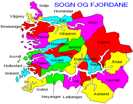
The municipalities
Source: Statistisk sentralbyrå
| Municipality | Pop. 1990 | Pop. 2000 | Km2/miles2 |
|---|---|---|---|
| 1401 Flora | 9 856 | 11 226 | 693/268 |
| 1411 Gulen | 2 606 | 2 489 | 596/260 |
| 1412 Solund | 1 144 | 959 | 228/88 |
| 1413 Hyllestad | 1 751 | 1 554 | 259/100 |
| 1416 Høyanger | 4 864 | 4 677 | 907/350 |
| 1417 Vik | 3 079 | 2 965 | 828/320 |
| 1418 Balestrand | 1 627 | 1 513 | 430/166 |
| 1419 Leikanger | 2 230 | 2 183 | 185/71 |
| 1420 Sogndal | 6 228 | 6 666 | 745/288 |
| 1421 Aurland | 1 834 | 1 833 | 1 489/575 |
| 1422 Lærdal | 2 204 | 2 202 | 1 341/518 |
| 1424 Årdal | 6 257 | 5 797 | 979/378 |
| 1426 Luster | 5 172 | 5 003 | 2 702/1 043 |
| 1428 Askvoll | 3 289 | 3 349 | 322/124 |
| 1429 Fjaler | 3 267 | 2 964 | 418/161 |
| 1430 Gaular | 2 849 | 2 886 | 579/224 |
| 1431 Jølster | 3 026 | 2 957 | 664/256 |
| 1432 Førde | 8 505 | 10 473 | 590/228 |
| 1433 Naustdal | 2 719 | 2 736 | 369/142 |
| 1438 Bremanger | 4 568 | 4 170 | 831/321 |
| 1439 Vågsøy | 6 373 | 6 479 | 166/64 |
| 1441 Selje | 3 299 | 3 066 | 236/91 |
| 1443 Eid | 5 681 | 5 780 | 468/181 |
| 1444 Hornindal | 1 217 | 1 227 | 191/74 |
| 1445 Gloppen | 6 141 | 5 769 | 1 022/395 |
| 1449 Stryn | 6 754 | 6 666 | 1 382/534 |
Up to the map!