

![[backarrow]](b_arrow.gif) :tilbake til hovedsida..........jump to the English main page:
:tilbake til hovedsida..........jump to the English main page:
![[english-arrow]](c_arrow.gif)

Nord-Trøndelag county
Below you'll find
- a map showing the county and all of its municipalities,
- a table showing the population and size of each municipality.
As a basis for this map is used a .bmp-file in a program called HYPERNOR v. 1.0., distributed by Programvareklubben MCS, Pb. 3541, 7002 Trondheim, Norway. Some corrections and the adaptation to HTML has been done by Johan I. Borgos. (Please include this statement if you copy this page and use it on a website or on printed matters.)
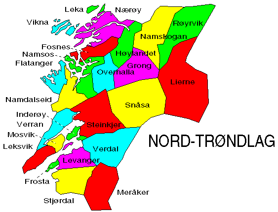
The municipalities
Source: Statistisk sentralbyrå
| Municipality | Pop. 1990 | Pop. 2000 | Km2/miles2 |
|---|---|---|---|
| 1702 Steinkjer | 20 577 | 20 459 | 1 563/603 |
| 1703 Namsos | 11 840 | 12 325 | 775/299 |
| 1711 Meråker | 2 750 | 2 637 | 1 273/492 |
| 1714 Stjørdal | 17 276 | 18 238 | 923/356 |
| 1717 Frosta | 2 503 | 2 430 | 76/29 |
| 1718 Leksvik | 3 589 | 3 512 | 431/166 |
| 1719 Levanger | 16 704 | 17 501 | 656/253 |
| 1721 Verdal | 13 391 | 13 644 | 1 548/598 |
| 1723 Mosvik | 964 | 925 | 219/85 |
| 1724 Verran | 3 139 | 2 733 | 602/232 |
| 1725 Namdalseid | 2 011 | 1 831 | 769/297 |
| 1729 Inderøy | 5 816 | 5 802 | 146/56 |
| 1736 Snåsa | 2 526 | 2 397 | 2 329/899 |
| 1738 Lierne | 1 694 | 1 565 | 2 972/1 147 |
| 1739 Røyrvik | 742 | 595 | 1 587/613 |
| 1740 Namsskogan | 1 188 | 989 | 1 416/547 |
| 1742 Grong | 2 488 | 2 565 | 1 140/440 |
| 1743 Høylandet | 1 409 | 1 335 | 756/292 |
| 1744 Overhalla | 3 777 | 3 659 | 730/282 |
| 1748 Fosnes | 858 | 794 | 546/211 |
| 1749 Flatanger | 1 436 | 1 238 | 458/177 |
| 1750 Vikna | 3 747 | 3 867 | 310/120 |
| 1751 Nærøy | 5 581 | 5 353 | 1 065/411 |
| 1755 Leka | 852 | 714 | 108/42 |
Up to the map!