

![[backarrow]](b_arrow.gif) :tilbake til hovedsida..........jump to the English main page:
:tilbake til hovedsida..........jump to the English main page:
![[english-arrow]](c_arrow.gif)

Troms county
Below you'll find
- a map showing the county and all of its municipalities,
- a table showing the population and size of each municipality.
As a basis for this map is used a .bmp-file in a program called HYPERNOR v. 1.0., distributed by Programvareklubben MCS, Pb. 3541, 7002 Trondheim, Norway. Some corrections and the adaptation to HTML has been done by Johan I. Borgos. (Please include this statement if you copy this page and use it on a website or on printed matters.)
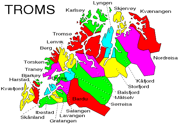
The municipalities
Source: Statistisk sentralbyrå
| Municipality | Pop. 1990 | Pop. 2000 | Km2/miles2 |
|---|---|---|---|
| 1901 Harstad | 22 384 | 23 025 | 364/141 |
| 1902 Tromsø | 50 548 | 59 145 | 2 558/988 |
| 1911 Kvæfjord | 3 425 | 3 287 | 522/202 |
| 1913 Skånland | 3 409 | 3 109 | 494/191 |
| 1915 Bjarkøy | 723 | 602 | 75/29 |
| 1917 Ibestad | 2 229 | 1 763 | 242/93 |
| 1919 Gratangen | 1 483 | 1 345 | 313/121 |
| 1920 Lavangen | 1 149 | 1 052 | 304/117 |
| 1922 Bardu | 3 890 | 3 889 | 2 6981 041 |
| 1923 Salangen | 2 586 | 2 346 | 457/176 |
| 1924 Målselv | 7 420 | 7 054 | 3 322/1282 |
| 1925 Sørreisa | 3 438 | 3 294 | 361/139 |
| 1926 Dyrøy | 1 587 | 1 337 | 290/112 |
| 1927 Tranøy | 1 992 | 1 695 | 523/202 |
| 1928 Torsken | 1 310 | 1 166 | 246/95 |
| 1929 Berg | 1 224 | 1 111 | 288/111 |
| 1931 Lenvik | 10 899 | 11 039 | 895/346 |
| 1933 Balsfjord | 6 378 | 5 749 | 1 494/577 |
| 1936 Karlsøy | 2 774 | 2 496 | 1 040/402 |
| 1938 Lyngen | 3 557 | 3 225 | 810/313 |
| 1939 Storfjord | 1 836 | 1 872 | 1 538/593 |
| 1940 Gáivuotna - Kåfjord | 2 857 | 2 369 | 997/385 |
| 1941 Skjervøy | 3 082 | 2 934 | 473/183 |
| 1942 Nordreisa | 4 697 | 4 821 | 3 435/1 326 |
| 1943 Kvænangen | 1 615 | 1 435 | 2 110/815 |
Up to the map!