

![[backarrow]](b_arrow.gif) :tilbake til hovedsida..........jump to the English main page:
:tilbake til hovedsida..........jump to the English main page:
![[english-arrow]](c_arrow.gif)

Four panoramas
I guess you may find estethically as well as technically much better panorama photos elsewhere on the Net. And they will most probably be real panoramas. Not composites, as the collection below. They are each made up of three photos stitched together, almost seamlessly, thanks to a nice program called "Photo Stitch".
I have used a wide-angle lens (23 mm), and no tripod. The first and the third panorama cover 100 degrees of the horizon, the other two 120 degrees.
Panorama 1: Skogsøya viewed from east
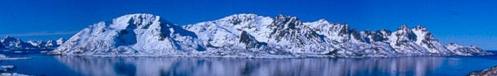
Skogsøya resembles roughly a square measuring six by six km, or a little less than four miles each way. Here we see the island from the east. The leftmost mountain is called Øksnesheia.
This side of the island had three farms or little hamlets, from left to wright: Tilset, Fjellgrimstad and Frivågen. They were abandoned in the 1950s for many reasons. One of them was the lack of a road.
This is a March landscape after a snowy winter (1994/95). The sun hasn't managed to melt away the white blanket yet. No spring rain to help it. Even the shores are white, that means a heavy snowfall only a few days ago. The black mountain-sides are too steep for the snow to stay.
Panorama 2: Turning 180o
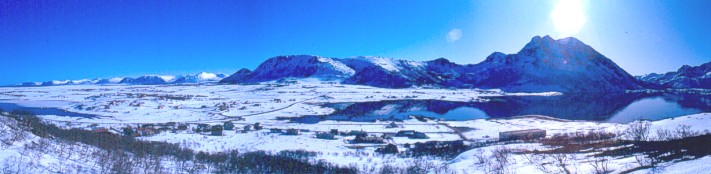
I'm standing at Langøya (Long Island!), or rather at the little Sommarøya (The Summer Island), which is now connected to its much bigger neighbor. In the left half of this panorama you can see a low and narrow strip of land between two bays sticking in from each side. The land is still rising after getting rid of the ice cap ten thousand years ago, so a shallow inlet eventually became dry land.
The nearest mountains tower over wide expances of flat land, mostly bogs. The highest peak is Staven at 596 meter (1,955 feet). The long and distant range to the left is another island, Andøya. Confused? Look at the Vesterålen map to get the big picture. I'm standing just below the red mark with number four.
A bog (or marsh) is called "myr" in Norwegian, the same word as English moor. If I had pointed my camera more to the left, you would have seen the administrative center in Øksnes. Its name is Myre, in English "The bogs".
Panorama 3: Skogsøya viewed from south
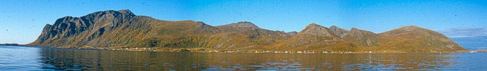
This is the southern and softer side of Skogsøya, photographed on a sunny day in the magnificent autumn of 1984. We have reached September, and still no rain, no clouds, no storms. I'm sitting in my boat on a very calm sea, taking the photos that make up this panorama.
This time the rounded form of Øksnesheia can be seen at far right. The highest top on the island is Stikollen, in the left half of the photo. It reaches 708 meter (2,323 feet). Autumn leaves on the birch trees paint the mountain sides brown.
This side of Skogsøya is still populated. From the left you can see the houses at Hjellsand (far left), Tunstad (the middle part) and Breistrand (last houses to the right). Øksnes with its church can't be seen on this panorama. It lies on the souteastern corner of the island.
Panorama 4: Sortland and Langøya viewed from east
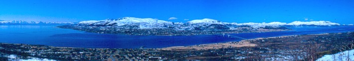
Here I'm standing on a mountain-side at Hinnøya, the largest island i Norway, looking over to Langøya, the third largest. A long bridge (1,000 meter or 3,280 feet) connects the two islands.
Sortlandssundet (The Sortland Inlet) stretches to the north (right) and south (left). The distant row of mountains to the left are the Lofoten islands, fifty km (thirty miles) away, as the crow flies. Again, look at the Vesterålen map!
It's early April, and the snow has gone in the lowland. On the other side of Sortlandssundet the houses in the little town Sortland are almost impossible to see. The town stretches along the shore from the bridge and to the left. On "my" side of the bridge you can see a strip of farming land, still light brown so early in the year.