

![[backarrow]](b_arrow.gif) :tilbake til hovedsida..........jump to the English main page:
:tilbake til hovedsida..........jump to the English main page:
![[english-arrow]](c_arrow.gif)

Kart over Norge ~ Norway map
(Vesterålen som utsnitt ~ Vesterålen inserted)
Klikk på et fylke for informasjon (på engelsk...) i tabellen lenger ned på sida. Der kan du trykke på pila til høyre for å se kart og tabell over kommunene der. [Click a county on the map to get information (in English!) in the table lower on the page. There you can push the arrow to the right to see a more detailed map of the county and a list showing all 'kommuner' (minicipalities) there.]
As a basis for this map is used a .bmp-file in a program called HYPERNOR v. 1.0., distributed by Programvareklubben MCS, Pb. 3541, 7002 Trondheim, Norway. Some corrections and the adaptation to HTML has been done by Johan I. Borgos. (Please include this statement if you copy this page and use it on a website or on printed matters.)
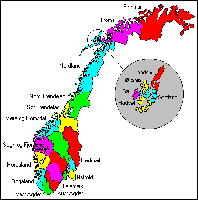
Fylkene i Norge ~ The counties of Norway
Noen enkle fakta ~ some elementary facts
Source for population and area figures: Statistisk sentralbyrå
| County | Bef./pop. 1950 2000 |
Areal km2 miles2 |
Kort omtale [short description] |
Mer [more] |
|---|---|---|---|---|
| Akershus | 183 116 467 052 |
4 587 1 771 |
Akershus, the second most populous county in Norway, encompasses the capital, Oslo, which has a slightly larger population. Almost every fourth Norwegians lives in these two counties. The name Akershus is borrowed from the castle and fortress at Aker, which is now a part of Oslo. And Aker of course means acre. Up to the map. | |
| Aust- Agder |
75 811 102 178 |
8 485 3 276 |
Aust-Agder together with its neighbour Vest-Agder constitute the southernmost part of Norway, usually called Sørlandet - The Southern Land. The valley Setesdalen runs through the county up to its northern border. Aust-Agder means 'the eastern part of Agder', and the meaning of the name Agder could be something like 'the land that jots out into the sea'. Up to the map. | |
| Buskerud | 156 220 236 811 |
13 856 5 349 |
Two long valleys - Numedal and Hallingdal - dominate the landscape of Buskerud, which is almost completely landlocked, save for a coastal strip in its southeastern end. The county has inherited its name from the farm Buskerud, 'the Bishops clearing', where the Bishop and later the bailiff lived. Up to the map. | |
| Finnmark | 64 511 74 059 |
45 879 17 713 |
Finnmark is the largest and the northernmost county in Norway, and also the newest in the kingdom. The borders to Sweden, Finland and Russia were drawn after 1750. Long fjords and a vast inland plain dominates the topography. The name Finmark means literally 'the land of the Sami', and it is still true: A majority of the Sami people lives there. Some of the oldest traces of stone age settlements in Norway - up to ten thousand years of age - have been found in Finnmark. Up to the map. | |
| Hedmark | 173 167 187 103 |
26 120 10 084 |
In the landlocked county of Hedmark you'll find Norways longest valley, Østerdalen (The Eastern Valley), and its longest river, Glomma. Hedmark borders to Sweden in all its length. The county name means 'the land of the Heides'. This was an old tribe that was called so because they lived in the forrested wilderness, 'heidr' in Old Norse. Up to the map. | |
| Hordaland | 311 132 435 219 |
14 962 5 777 |
Hordaland count is a part of 'Vestlandet' - The Western Land. Two thirds of the countys population live in Bergen, Norways second largest city. The long Hardanger Fjord in the south and numerous small and big islands along the coast are main landscape features in this county. Hordaland means 'the land of the Hordar', a tribe with a name of possibly Celtic origin. Up to the map. | |
| Møre og Romsdal |
191 621 243 158 |
14 596 5 636 |
This county constitutes the northern part of 'Vestlandet' - The Western Land. Numerous fjords, wild mountains and many islands dominates the nature in Møre and Romsdal. The first part of the county name probably derives from 'mare', an old word for sea. If that is true Møre means 'the land by the sea'. Romsdal, the central part of the county, takes its name from the valley where the river Rauma flows to the sea. Up to the map. | |
| Nordland | 221 809 239 109 |
36 434 14 067 |
Nordland is by far the longest county in Norway, stretching more than four hundred miles, most of them north of the Arctic Circle, from south to north with islands and fjords. At its narrowest the distance between the sea and the Swedish border is only three miles. The biggest island group is Lofoten and Vesterålen Islands in the northern part. The name is a reminder from times when 'Nordlandene' - The Northern Lands - was used as a description of the three northern counties. Up to the map. | |
| Nord- Trøndelag |
109 948 127 108 |
20 777 8 022 |
This is the northern half of Trøndelag, the central part of Norway (see Sør-Trøndelag). The coastal side has the usual fjords and islands, and the Trondheim fjord cuts deep into the countys inland, where you'll find broad farming districts. The name Trøndelag means 'the district under the law of the Trønder', a kind of state that existed before the Viking era. The people who lived there was called 'Trønder', a name of uncertain origin. Up to the map. | |
| Oppland | 160 496 182 701 |
23 827 9 200 |
Oppland is landlocked, like its neighbour Hedmark to the east. The county stretches from broad farmland in the south, where you'll also find the lake Mjøsa (Norways largest), to the Rondane, Dovre and Jotunheimen mountain ranges in the north. Among its many valleys Gudbrandsdalen is the longest. Gudbrandsdalen and Mjøsa meets near the town Lillehammer. The name Oppland means 'The High Land' (compared with the lower districts bordering the Oslo fjord). Up to the map. | |
| Oslo | 434 365 507 467 |
427 165 |
Norways capital and largest city, the thousand years old Oslo, is situated at the head of the Oslo fjord. After a fire in 1624 the city was rebuild and renamed Christiania in honor of a Danish king. The spelling was later changed to Kristiania, but in 1925 the city got its old name back. There are many different interpretations of this name. The first syllable may come fram 'ás' - God (in the Old Norse belief), and the second 'an open place'. Up to the map. | |
| Rogaland | 211 512 373 210 |
8 553 3 295 |
The county of Rogaland lies at Norways southwestern tip, with the North Sea washing its shores. The Bokn fjord dominates the northern part of the county, in the south you'll find one of the most fertile farmland in Norway - the coastal strip called Jæren. Behind Jæren barren hills stretches eastward. The name Rogaland means 'the land of the Ryger'. The Ryger tribe is believed to have settled there two thousand years ago. The meaning of the tribe name is uncertain. Up to the map. | |
| Sogn og Fjordane |
97 714 107 589 |
17 864 6 897 |
Sogn and Fjordane - the central parts of Vestlandet (The Western Land) - has, as the last part of its name tells, many fjords, and the longest (205 km or 127 miles long) is the Sogne fjord, which has contributed with its own original name to the county. Nordfjord (The Northern fjord) near the border to Møre and Romsdal, is notable, too. The old fjord name Sogn may have something to do with strong currents in the sea. Up to the map. | |
| Sør- Trøndelag |
197 687 262 852 |
17 839 6 888 |
This county is the southern half of Trøndelag (see comments on Nord-Trøndelag), and is situated at both sides of the Trondheim fjord. Two long valleys stretching south contain the main road and railway connections to the southern part of Norway - Gauldalen to Hedmark county and Orkdalen to Oppland county. More than half of the countys population lives in Trondheim (the home of the trønder), the third largest city in Norway. Up to the map. | |
| Telemark | 136 519 165 038 |
14 186 5 477 |
This county stretches from coastal lowland near the Skagerak in southeast, to the mountain plateau Hardangervidda in the northwest. Between these extremes you'll find numerous valleys, most of them containing long and narrow lakes. The countys name means 'the land of the Teler'. The tribe called Teler lived there long before the Viking era, and the tribe name is very old and difficult to explain. Before 1919 the coastal part of Telemark was called Grenland. Up to the map. | |
| Troms | 117 564 151 160 |
25 015 9 658 |
Long fjords, deep valleys, high mountains together with big islands along the coast make Troms county a Norway in miniature. A thousand years ago the rule of Norwegian kings and chieftains had its borders in the northern parts of Troms. More than a third of the countys population lives in the city of Tromsø, the main port to the Arctic waters. The main city is situated on the Troms island, which has given the name to the city (Danish 'ø' and Norwegian 'øy' means island) and the county. The origins of the name is uncertain. Up to the map. | |
| Vest- Agder |
96 942 155 691 |
6 817 2 632 |
Vest-Agder is the western part of Agder (see Aust-Agder). According to the medieval Icelandic historian Snorri Sturlasson Agder was ruled by local kings before the creation of the Norwegian kingdom in 872. Half of the population in this county now lives in Kristiansand, one of the main ports for ferry crossings to Denmark and England. Kristiansand has got the name from the Danish king who founded the city in the 1600s. Up to the map. | |
| Vestfold | 154 670 212 775 |
2 140 826 |
Many hundred years ago the Oslo fjord was called 'Fold', a word meaning open sea. Vestfold then means 'the land on the western side of Fold' (see the next county). Vestfold is the second smallest county in Norway (Oslo takes the bottom place). The county is almost without mountains, and has only very short fjords and small islands. But it has a very rich history! Up to the map. | |
| Østfold | 185 492 248 217 |
3 889 1 502 |
Østfold means 'the land on the eastern side of Fold' (se explanation for the previous county). The county is situated between the Oslo fjord and the Swedish border, and is filled with farmland and low forrested hills. Glomma, the longest river in Norway, runs through Østfold and reaches the sea there (see also Hedmark). Very old traces of stone age settlements have been found in this county. Up to the map. |